THE MARKUS TUNNEL

Visualisation of
the Markus Tunnel

SIZE AND GEOLOGICAL CONDITIONS

The Markus Tunnel, situated at 1,313 metres above sea level is the deepest of the mines in the Gand area and quite likely also the most recently created. Although it is assumed that it was driven into the mountain only in the 18th century, an exact determination of its date of origin has as yet been unsuccessful. Mountain waters emerge in the region of the pit and were once collected in a small water trough that was used to water the farm animals.

These waters, passing through the mines, must have contained traces of the (ore) minerals that were once mined here. Today, the Markus Tunnel can be accessed again as far as 54 metres deep into the mountain. The passage does not run horizontally along the trajectory of the hill, but has a westward tendency, approaching the area just below the Miners’ Tunnel. Their advancement directions therefore roughly correspond. This suggests that the second tunnel might have been driven into the mountain to reach the larger ore deposits.

St. Anton locals have reported that in the early 20th century, when the Markus Tunnel could still be accessed even deeper into the mountain, there was a large room inside. It is said that this chamber was the size of the church of St. Jakob am Arlberg. If the mine was as richly endowed with ore as it is assumed today, this could have been possible. This would not be the only place in the Tyrol where miners created caverns of this size. Since relevant documentation or maps of the mine are lacking, an exact determination of its overall size is, unfortunately, no longer possible.

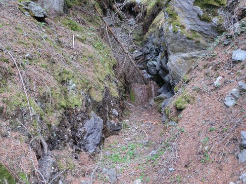
Fig.: Pinge at the entrance to the Markus Tunnel in 2017, before it was changed as part of the reconstruction works

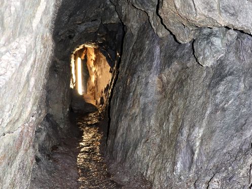
Fig.: 42 metres deep into the Markus Tunnel, moving westward towards the cave-in section at the end of the tunnel

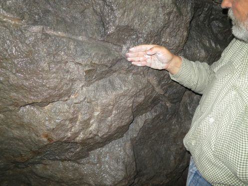
Fig.: Drilling track near the entrance of the Markus Tunnel some 20 metres deep into the mountain, with a diameter of 25 mm and a depth of 350 mm; the drilling was done in preparation of the ensuing blasting and, therefore, must have taken place after 1600.
 

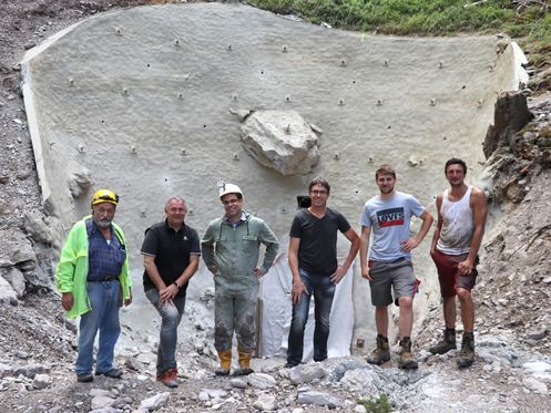
Fig.: During the preparation activities to reopen the Markus Tunnel, a 10 metres tall, anchored concrete wall had to be erected in 2018 to prevent further landslides. Involved in the extensive renovation of the tunnel were (from left to right) Dr. Peter Gstrein (head, scientific advisor, and editor of the project), Helmut Mall (mayor of St. Anton), Engineer Heinz Harrer (from the local mining office), Michael Rainer (representative of the local building authority), Manuel Venier (HTB site manager), and Frank Traxl (HTB).

1,313 metres ASL

The adit was driven into the mountain at 1,313 metres above sea level (ASL). As the passage was driven in a clear upward direction, it gains elevation as you progress into the mountain.

BLASTING

The Markus Tunnel was created by classical rock blasting method, i.e. the controlled use of explosives to break up the rock. Most likely, gunpowder was the explosive of choice in this specific case. The positions and depths of the drilling holes that are still visible today even suggest that the most recent work that was carried out here was connected to Engelbert Hindeland, who was active in this area between 1748 and 1762.

click to read next info board