THE MINERS’ HILL
AND THE SEARCH
FOR ORE

IN SEARCH OF ORE

If there is no ore, there is no mining. This is why the prospector is often considered the most important person in mining. Prospectors are especially trained explorers, also known in Austria as “Walen”. The term “Venediger (Mandln)” is very common in the St. Anton region and is also found in many ancient Central European tales. It has been determined that these almost mythical figures, often described as swarthy men of small stature, were actually prospectors.

They were commissioned by mining companies to comb the mountains using special prospecting techniques, which should help them detect ore as quickly as possible. Exposed rock was ideal, since ore or signs of mineralisation were immediately visible. Talus deposits at the base of crags or screes along the foot of a cliff also facilitated the prospector’s work and allowed for uncomplicated geological mapping.

Limonite identification, a method almost forgotten today, was considered an infallible prospecting method. Another popular technique used in the search for ore was analysing surrounding vegetation and indicator plants, as well as specific plant associations or abnormal growth. Another equally important indicator used to determine the presence of ore was the presence of natural spring water. Dowsing, i.e. locating ore by the use of a divining rod, was also applied with great success.

Fig.: “Exploring ore by the rod or trial pit” adapted from M. F. Gaetzschmann, 1856 (Illustration © Oliver Kopp)
THE MINERS’ HILL

The hill on which you are standing is commonly referred to as “Knåppa-Bichl” (Miners’ Hill). Both this name and the shape of the hill have led people to believe that this is a mine dump, a pile of waste material and disposal site for displaced soil produced during the operation of the Gand mines. Ground surveys conducted during the creation of the Gand Mines circular walk, however, indicated that the hill does not

contain any material from the nearby mines; rather it consists of natural sediments. This is also supported by several other factors, including the absence of any other mine dumps of this volume located in the Tyrol. The angle of the hill’s slope also contradicts the assumption that this hill is composed of waste rock.

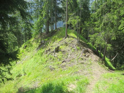
Fig.: Contrary to common belief, the Miners’ Hill (facing south) is not a former mine dump. In the bottom right corner, you can see a part of the old miners’ path.

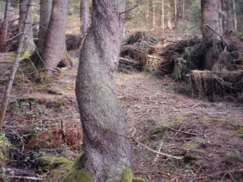
Fig.: Trunk of a spruce with a left-hand twist as well as fahlore and lead glance mineralisation at the bottom (from the Hötting mountain mine above Innsbruck)

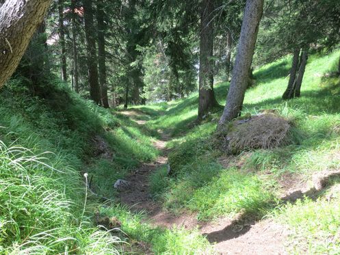
Fig.: The steep old mountain path used by the miners to ascend to the mines for work and descend to their homes after the end of each shift

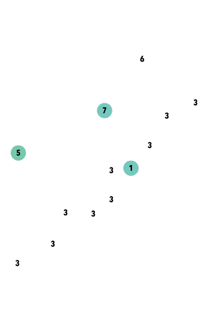
Fig.: Illustration of the method of geological mapping with longitudinal section of an Alpine streambed (Illustration © Oliver Kopp)
2
TALUS DEPOSITS AT THE BASE OF THE CRAG
3
BARREN BEDROCK
4
SCREE OF LOSE ROCK
1
LAYER OF ROCK CONTAINING THE ORE/MINERALISED ROCK TO BE EXCAVATED
3
BARREN BEDROCK
5
TRACES OF ORE IN THE STREAMBED
6
PART OF THE STREAMBED WITHOUT ORE TRACES
7
PRESUMED LOCATION OF THE ORE-BEARING ROCK
click to read next info board