the Geology

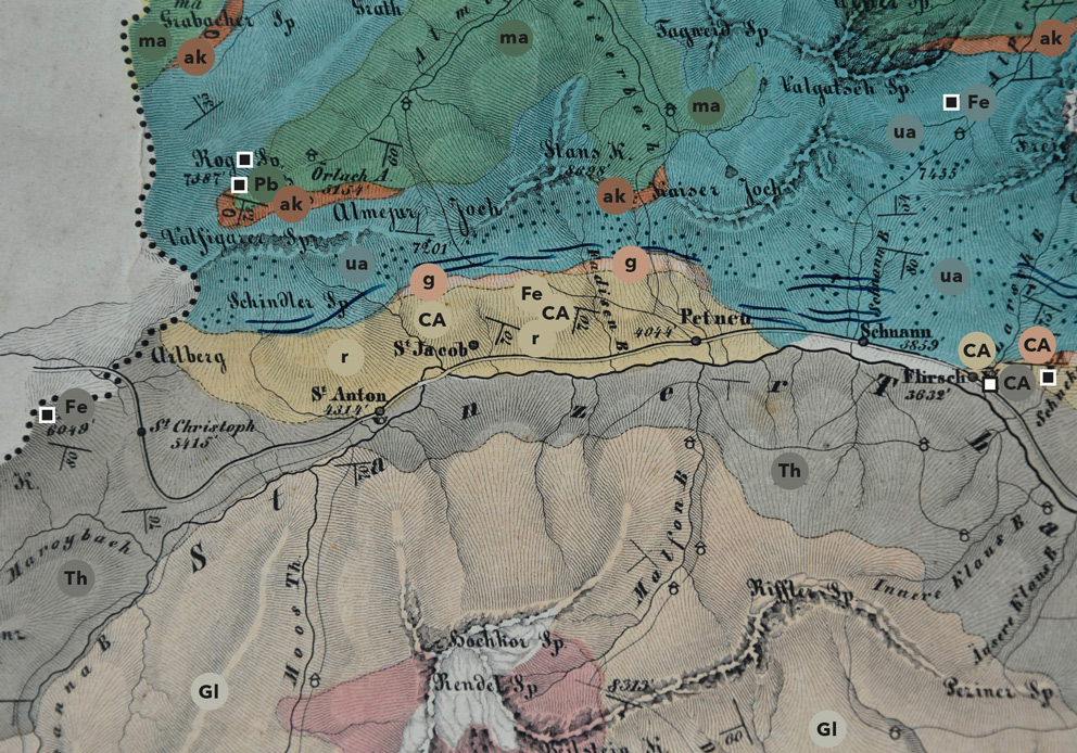
Fig.: Detail of the geognostic (= geological) map of the Tyrol from the archives of the geognostic mining society of the Tyrol and Vorarlberg, 1849.
TYPES OF ROCK
r
Red sandstone (= Alpine Verrucano)
g
Gneiss
Gl
Schist
Th
Slate
ak
Limestone (marble)
ua
Lower Alpine limestone
ma
Middle Alpine limestone
MINES
Mines in operation (1849)
Closed mines (1849)
CA
Fahlore
Fe
Iron ore
Pb
Lead ore
THE UPPER EASTERN ALPS

Over 90 % of the surface rock in North Tyrol were once sediments collected in the shallow shelf sea at the northern edge of the African (Apulian) Plate. During Alpine orogeny, these sediment layers were thrust northwards and collided with the southern edge of Europe, and now lie folded on top of each other. The Upper Eastern Alps, which is where the Gand mines are located, form the top layer.

ALPINE VERRUCANO

The Gand mines are situated amid Alpine Verrucano rock. The product of erosion of the Variscan mountains (a complex of overthrust and folded mountains named after the Variscan people, an ancient Bavarian tribe), Alpine Verrucano is mainly composed of sandstone and shale rock, as well as connecting sand-shale formations. Limestone can also be found in several places across the area. The varying quantities of limestone are determined by the ever-changing conditions that influence rock formation.

This is because pure river sediment tends to result in sandier deposits than still waters, which usually lead to the formation of clay. Alpine Verrucano forms the base of the Lechtal Alps, which are part of the greater Northern Limestone Alps located uphill to the north of here. In the process of Alpine orogeny, these once horizontally deposited rocks were folded to a near-vertical state and were moved around in many different directions by the colliding tectonic plates.

Schematic geological
north-south-profile
of the Gand mine

A
PARAGNEISS
B
PHYLLITE GNEISS
C
LANDECK QUARTZ PHYLLITE
D
ALPINE VERRUCANO
E
ALPINE RED SANDSTONE
F
ALPINE SHELL LIMESTONE
G
ARLBERG LAYERS
H
MAIN DOLOMITE AND RAIBL FORMATION
J
JURASSIC LIMESTONE
I
KÖSSEN FORMATION
K
GENERAL JURASSIC LAYERS

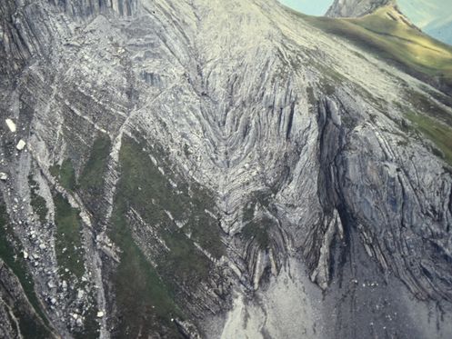
Fig.: Folds of the main dolomite in the main ridge of the Lechtal Alps to the north-east of Gand (in the Grießkopf area)

click to read next info board